


THE RIGHT TOOL FOR EVERY DOMAIN
ES2 invests in industry-leading equipment across Air, Land, and Sea so our teams can deliver the precision and resolution your project demands. From fixed-wing UAS to multibeam sonar, here's what we bring to the field.
AIR
UAS Aircraft Fleet
ES2 operates a fleet of professional fixed-wing and multi-rotor UAS platforms flown by FAA-certified Remote Pilots in Command. Each airframe is matched to a mission profile — wide-area coverage, heavy payload LiDAR, or operations over people.

AIR
WingtraOne Gen II PPK
The WingtraOne GEN II is a high-precision mapping drone that offers the convenience of vertical take-off and landing (VTOL) and the endurance of a fixed-wing aircraft for surveying mid- to large-scale projects. The ES2 WingtraOne GEN II is equipped with a high-resolution 61MP Sony a7R DSLR camera, a PPK GNSS receiver, and the MicaSense RedEdge-P multispectral sensor, which provides six spectral bands (red, green, blue, near-infrared, red edge, panchromatic).

AIR
WingtraRAY
The latest aircraft in our fleet, the WingtraRAY, is the newest Wingtra platform and provides many improvements over the GENII. The RAY flies faster and the batteries last longer than those of the GENII, allowing for more extensive coverage in a single flight. New sensors, such as the MAP61 and SURVEY61, are available to survey faster and in greater detail. The RAY is equipped with a parachute to allow for operations over people.

AIR
Inspired Flight 1200A
Inspired Flight designs, develops, and manufactures commercial drones for Government use in the United States. Inspired Flight’s IF1200A is ideal for the most demanding applications, including utility inspection, LiDAR mapping, aerial photogrammetry, emergency response, government work, and more. Inspired Flight’s heaviest-lift aircraft is capable of a wide range of payload configurations to accomplish the job efficiently with maximum flight time and payload capacity.
-
Max Payload Weight: 19 pounds
-
Max Flight Time: 43 minutes
SENSORS
Sony RX1 RII
-
WingtraOne GEN II Payload
-
High accuracy
-
42 MP, full-frame sensor
-
35 mm lens, nadir configuration
-
Payload weight 590 g (1.27 lb)
-
Max coverage (400 ft agl) up to 550 ac at 0.63 in GSD
-
Lowest possible GSD 0.28 in/px at 170 ft agl
-
Horizontal Accuracy: Down to 2 cm
-
Vertical Accuracy: Down to 3 cm

SENSORS
Wingtra RBG61 (Sony A7R)
-
WingtraOne GEN II Payload
-
High accuracy and efficiency
-
61 MP, full-frame sensor
-
24 mm lens, nadir configuration
-
Payload weight 709 g (1.56 lb)
-
Max coverage (400 ft agl) up to 760 ac at 0.74 in GSD
-
Lowest possible GSD 0.28 in/px at 147 ft agl
-
Horizontal Accuracy: Down to 3 cm
-
Vertical Accuracy: Down to 3 cm
.png)
SENSORS
Wingtra MAP61
-
WingtraRAY Payload
-
Efficiency and 3D
-
61 MP, full-frame sensor
-
17 mm lens, low oblique configuration
-
Payload weight 585 g (1.29 lb)
-
Max coverage (400 ft agl) up to 1,360 ac at 1.06 in GSD
-
Lowest possible GSD 0.47 in/px at 180 ft agl
-
Horizontal Accuracy: Down to 3 cm
-
Vertical Accuracy: Down to 3 cm
SENSORS
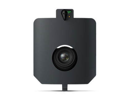
Wingtra SURVEY61
-
WingtraRAY Payload
-
High Accuracy
-
61 MP, full-frame sensor
-
35 mm lens, nadir configuration
-
Payload weight 585 g (1.29 lb)
-
Max coverage (400 ft agl) up to 770 ac at 0.51 in GSD
-
Lowest possible GSD 0.2 in/px at 150 ft agl
-
Horizontal Accuracy: Down to 3 cm
-
Vertical Accuracy: Down to 3 cm

SENSORS
MicaSense RedEdge-P
-
WingtraOne GEN II Payload
-
Multispectral
-
R, G, B, RE, NIR, 5.5 mm lenses
-
5 x 1.58 MP
-
Panchromatic band, 10.3 mm lens, 1 x 5.1 MP
-
Nadir configuration
-
Payload weight 502 g (1.1 lb)
-
Max coverage (400 ft agl) up to 380 ac at 3.2 in GSD
-
Lowest possible GSD: 0.78 in/px at 195 ft agl

SENSORS
GeoCue TrueView 660
-
IF1200A Payload
-
Data Collection: LiDAR + Imagery
-
Laser Scanner: RIEGL miniVUX-3UAV
-
LiDAR Range – 100 m for targets with > 20% reflectivity
-
LiDAR Beams/Returns: Up to 5 per outgoing pulse
-
Pulse Repetition Rate: 300 kHz
-
Trimble APX-20 IMU
-
Accuracy: Better than 5 cm, RMSE
-
Precision: Better than 2.5 cm at 1 σ
-
Camera Sensor: 3 Sony IMX-183: 1”, 20 MP, RGB -> 60 MP per payload.
-
Mass: 2.6 kg

LAND
GNSS, Optical & Mobile Survey
ES2 field crews use the latest Trimble GNSS receivers, robotic total stations, and mobile reality capture platforms to deliver high-accuracy terrestrial data for construction, topographic, and control surveys.

LAND
Trimble R-Series GNSS
-
ES2's GNSS receivers deliver high-accuracy positioning for survey control, topographic surveys, and construction layout, even in the most challenging environments.
-
RTK and PPK GNSS positioning
-
Centimeter-level horizontal and vertical accuracy
-
Rapid satellite acquisition for efficient field work
-
Rugged design built for all-weather field conditions
LAND
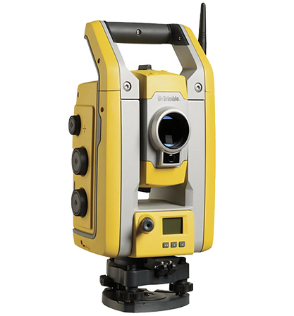
Trimble S5 Robotic
-
The S5 robotic total station gives ES2 field crews single-operator efficiency for construction layout, as-built surveys, and topographic mapping, combining optical precision with robotic tracking to speed up data collection.
-
Robotic, single-operator total station
-
High-speed, high-accuracy angle and distance measurement
-
Advanced target lock and tracking technology
-
Integrates directly with Trimble Business Center for streamlined office processing

LAND
Trimble Catalyst
-
Trimble Catalyst turns a standard tablet or device into a flexible, software-defined GNSS receiver, giving ES2 crews a lightweight option for mobile GIS data collection and field verification.
-
Software-defined GNSS receiver
-
Subscription-based accuracy levels, scalable to project needs
-
Pairs with mobile GIS apps for streamlined field-to-office workflows
-
Lightweight, low-profile design for fast deployment

LAND
NavVis MLX
-
The NavVis MLX is a wearable mobile mapping system that lets ES2 capture dense, georeferenced 3D reality data on foot, ideal for as-built documentation and complex sites where traditional scanning is slower or less practical.
-
Wearable, handheld mobile LiDAR and reality capture system
-
Simultaneous localization and mapping (SLAM) technology
-
High-density 3D point cloud generation in motion
-
Speeds up data capture for as-built and topographic deliverables
SEA
Sonar & Hydrographic Systems
ES2 operates purpose-built marine survey vessels and professional-grade sonar systems to deliver bathymetric and hydrographic data for USACE, Gulf Coast ports, and coastal infrastructure clients.

SEA
SAFE Boat Porter 78S
-
ES2's SAFE Boat Porter 78S serves as a stable, purpose-built survey vessel for hydrographic data collection, supporting single beam and multibeam sonar operations on rivers, ports, and coastal waterways.
-
Purpose-built aluminum hydrographic survey vessel
-
Stable platform for single-beam and multibeam sonar systems
-
Configured for USACE, port, and coastal survey operations
-
Supports integration with Mythos AI autonomous survey technology

SEA
Kongsberg EM 2042
-
The Kongsberg EM 2042 multibeam echosounder gives Es² high-resolution seafloor mapping capability for hydrographic surveys, dredging support, and channel condition surveys to IHO and USACE standards.
-
High-resolution multibeam echosounder
-
Wide swath coverage for efficient bathymetric data collection
-
Meets IHO and USACE hydrographic survey accuracy standards
-
Pairs with HYPACK for survey planning and data processing
READY TO TALK ABOUT YOUR NEEDS?
Whether you're a federal contracting officer, state & local agency, or port authority leader, or an AEC firm evaluating teaming options, we're ready to discuss your scope and how ES2 can support your program.