


MARKETS WE SERVE
From the field to the boardroom, ES2 brings specialized geospatial expertise to the teams and organizations that need it most. We partner with architects, engineers, construction firms, port authorities, state and local governments, and federal agencies, delivering the accuracy, capacity, and technical depth that keep complex projects moving—across air, land, and sea.
30+
years





WE SPECIALIZE IN WORKING WITH


Architecture & Engineering
As a deployment-ready partner, we deliver specialized geospatial expertise and capacity to Architecture & Engineering teams. Our professionals provide UAS/drone mapping, land and hydrographic surveying, GIS analysis, and specialized capabilities that keep projects moving. From concept through project completion, we help improve project accuracy, efficiency, and delivery confidence.


Construction
We provide construction firms with the specialized surveying and GIS capacity needed to keep projects on schedule and on budget. Our crews provide construction surveying, including stakeouts, compliance surveys, site control, volume calculations, cross sections, drone mapping, GIS field inspection forms, and real-time tracking dashboards.


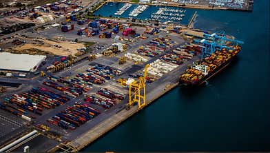
Maritime Ports
Through strategy implementation, GIS services, and data collection, we help port authorities chart their digital twin journey, advancing operational visibility to manage assets, respond to incidents, and make the case for growth. We integrate GIS with your business systems, including real estate, assets, AIS/real-time vessel management, and port community systems.


State & Local Government
We help City, County & Parish, State, and other agencies connect departments, streamline workflows, and eliminate data silos. Through GIS strategies and solutions, we promote improved collaboration, more informed decision-making, and help agencies meet growth objectives while better serving their communities.


ES2 CLIENTS


