.png)
(225) 927-7171

UAS Mapping
Es² maintains a highly-trained staff of FAA certified Remote Pilots in Command, registered professional engineers and surveyors, and certified GIS Professionals to provide wide range of UAS-based data products and services.

Es² UAS Mapping Services


Es² Aircraft


Es² Sensors
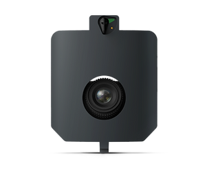
Sony RX1 RII
-
WingtraOne GEN II Payload
-
High accuracy
-
42 MP, full-frame sensor
-
35 mm lens, nadir configuration
-
Payload weight 590 g (1.27 lb)
-
Max coverage (400 ft agl) up to 550 ac at 0.63 in GSD
-
Lowest possible GSD 0.28 in/px at 170 ft agl
-
Horizontal Accuracy: Down to 2 cm
-
Vertical Accuracy: Down to 3 cm

Wingtra RBG61 (Sony A7R)
-
WingtraOne GEN II Payload
-
High accuracy and efficiency
-
61 MP, full-frame sensor
-
24 mm lens, nadir configuration
-
Payload weight 709 g (1.56 lb)
-
Max coverage (400 ft agl) up to 760 ac at 0.74 in GSD
-
Lowest possible GSD 0.28 in/px at 147 ft agl
-
Horizontal Accuracy: Down to 3 cm
-
Vertical Accuracy: Down to 3 cm

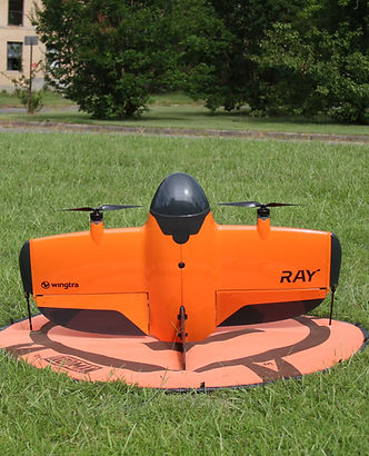
Wingtra MAP61
-
WingtraRAY Payload
-
Efficiency and 3D
-
61 MP, full-frame sensor
-
17 mm lens, low oblique configuration
-
Payload weight 585 g (1.29 lb)
-
Max coverage (400 ft agl) up to 1,360 ac at 1.06 in GSD
-
Lowest possible GSD 0.47 in/px at 180 ft agl
-
Horizontal Accuracy: Down to 3 cm
-
Vertical Accuracy: Down to 3 cm
Wingtra SURVEY61
-
WingtraRAY Payload
-
High Accuracy
-
61 MP, full-frame sensor
-
35 mm lens, nadir configuration
-
Payload weight 585 g (1.29 lb)
-
Max coverage (400 ft agl) up to 770 ac at 0.51 in GSD
-
Lowest possible GSD 0.2 in/px at 150 ft agl
-
Horizontal Accuracy: Down to 3 cm
-
Vertical Accuracy: Down to 3 cm

Micasesense RedEdge-P
-
WingtraOne GEN II Payload
-
Multispectral
-
R, G, B, RE, NIR, 5.5 mm lenses
-
5 x 1.58 MP
-
panchromatic band, 10.3 mm lens,
-
1 x 5.1 MP
-
nadir configuration
-
Payload weight 502 g (1.1 lb)
-
Max coverage (400 ft agl) up to 380 ac at 3.2 in GSD
-
Lowest possible GSD 0.78 in/px at 195 ft agl

GeoCue TrueView 660
-
IF1200A Payload
-
Data Collection: LiDAR + Imagery
-
Laser Scanner: RIEGL miniVUX-3UAV
-
LiDAR Range – 100 m for targets with > 20% reflectivity
-
LiDAR Beams/Returns: Up to 5 per outgoing pulse
-
Pulse Repetition Rate: 300 kHz
-
Trimble APX-20 IMU
-
Accuracy: Better than 5 cm, RMSE
-
Precision: Better than 2.5 cm at 1 σ
-
Camera Sensor: 3 Sony IMX-183: 1”, 20 MP, RGB -> 60 MP per payload.
-
Mass: 2.6 kg

Es² UAS Projects


Our Pilots

Andrew Milanes, PE
FAA Drone Pilot

Josh Boudreaux, CST
FAA Drone Pilot

Brennon Albarez, PLS
FAA Drone Pilot

Trey King, CST
FAA Drone Pilot

Chad Netto, GISP
FAA Drone Pilot
_edited.jpg)
Anthony Gallodoro
FAA Drone Pilot